See full article: https://doi.org/10.1016/j.ufug.2026.129775
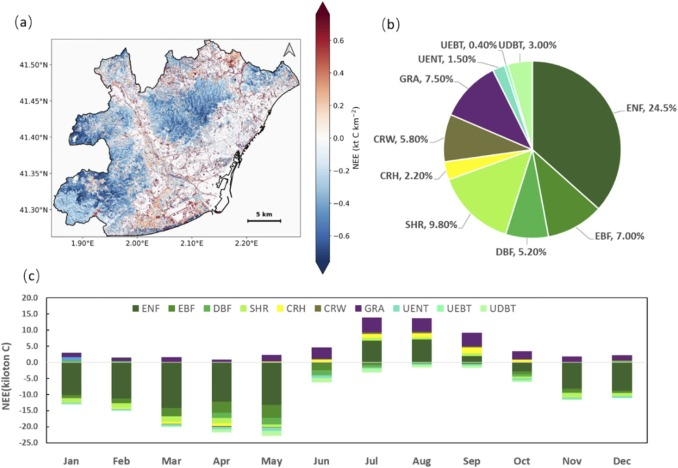
Abstract: To advance urban sustainability and achieve climate neutrality, cities are proposing various decarbonization strategies such as implementation of green infrastructures (GI). However, the heterogeneity of urban landscapes—characterised by distinct climatic and soil conditions and temporal variability—complicates the quantification of the urban biosphere’s CO2 mitigation potential, resulting biogenic CO2 fluxes or inventories are rarely available to local urban planners. Here we present an accessible, high resolution (10m) method combining public satellite and city data with an improved version of the Vegetation Photosynthesis and Respiration Model (VPRM). Applying this method to the Metropolitan Area of Barcelona (AMB) (2023) reveals that GI (67% cover) has a net carbon flux of −77 kt C, offsetting 3% of annual anthropogenic CO2 emissions (2450kt C), peaking at an 11% offset in Spring. Uptake is dominated by evergreen needleleaf forests (85%), whereas grasslands and summer croplands act as net sources. A cross-city comparison of biogenic CO2 fluxes show that higher green cover does not yield a proportional sink increase, underscoring the need for strategic, standardized spatial planning to maximize urban climate mitigation.
Keywords: green infrastructures; biogenic CO2 fluxes; biosphere model; biogenic uptake; urban carbon budget; climate mitigation